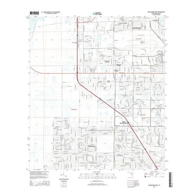
2015 Map of Melbourne West
USGS Topo · Published 2015About this map
The Saint Johns River and the marshy edges of Lake Washington define the western reaches of this Brevard County landscape, showing the hydrologic character of the Florida coast. This modern survey documents the extensive suburban expansion of Palm Bay and West Melbourne, where complex residential street grids now fill the spaces between historic transport corridors. The map highlights the significant infrastructure of the Melbourne International Airport and the commercial density developing around W New Haven Ave. Smaller community enclaves like Melbourne Village, June Park, and Mintons Corner are clearly delineated, illustrating how once-distinct settlements have integrated into a continuous urban corridor. In the south, the Melbourne Tillman Canal serves as a critical marker of the region's managed water systems, cutting through the dense development of the Space Coast's residential heart.
Find a feature on this map
22 named features on this map. Tap any name to fly to it.
Don’t see what you’re looking for? This feature index may not catch every label — zoom into the map to look around manually.
Map Details
Editions of this 2015 Melbourne West Map
This is the sole edition of this map. No revisions or reprints were ever made.
Other maps of this area

1949 · Melbourne West
USGS Topo · 1:24,000

1949 · Melbourne East
USGS Topo · 1:24,000

1949 · Eau Gallie
USGS Topo · 1:24,000

1949 · Grant
USGS Topo · 1:24,000

1949 · Tropic
USGS Topo · 1:24,000

1951 · Melbourne East
USGS Topo · 1:24,000

1951 · Eau Gallie
USGS Topo · 1:24,000

1951 · Melbourne West
USGS Topo · 1:24,000

1951 · Grant
USGS Topo · 1:24,000
1951 · Tropic
USGS Topo · 1:24,000