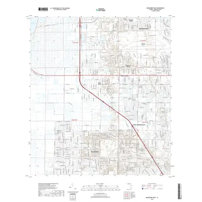
2018 Map of Melbourne West
USGS Topo · Published 2018About this map
Melbourne and the rapidly developing corridor of Palm Bay dominate this eastern Florida landscape, showing a dense network of suburban expansion integrated with critical water management systems. The Melbourne-Tillman Canal and its associated drainage channels illustrate the sophisticated engineering required to maintain these coastal communities against the backdrop of the Saint Johns Marsh. To the west, the wilder reaches of the Saint Johns River and Lake Washington provide a stark contrast to the structured grid of neighborhoods like June Park and Melbourne Village. The presence of the Melbourne International Airport and arterial routes like W New Haven Ave highlight the area's role as a regional transportation hub, while smaller named locales such as Mintons Corner and West Eau Gallie preserve the identity of the distinct settlements that have converged into this metropolitan expanse.
Find a feature on this map
27 named features on this map. Tap any name to fly to it.
Don’t see what you’re looking for? This feature index may not catch every label — zoom into the map to look around manually.
Map Details
Editions of this 2018 Melbourne West Map
This is the sole edition of this map. No revisions or reprints were ever made.
Other maps of this area

1949 · Melbourne West
USGS Topo · 1:24,000

1949 · Melbourne East
USGS Topo · 1:24,000

1949 · Eau Gallie
USGS Topo · 1:24,000

1949 · Grant
USGS Topo · 1:24,000

1949 · Tropic
USGS Topo · 1:24,000

1951 · Melbourne East
USGS Topo · 1:24,000

1951 · Eau Gallie
USGS Topo · 1:24,000

1951 · Melbourne West
USGS Topo · 1:24,000

1951 · Grant
USGS Topo · 1:24,000
1951 · Tropic
USGS Topo · 1:24,000