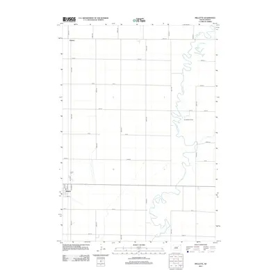
2012 Map of Mellette
USGS Topo · Published 2012About this map
The town of Mellette serves as the primary hub in this Spink County landscape, where the grid of rural section lines meets the meandering course of the James River. The town is organized around a small street network including Railway Ave and Cady St, indicating its historic orientation toward rail transportation. To the north, the small settlement of Duxbury and the location of Armadale Grove sit within a strictly surveyed agricultural interior. The presence of Calvary Cem north of the main town provides a specific point of interest for genealogical research in the area. The landscape is defined by the contrast between the rigid geometry of roads like Sunshine Rd and the serpentine path of the river, which is joined by Mud Cr as it flows southward through the eastern half of the quadrangle.
Find a feature on this map
27 named features on this map. Tap any name to fly to it.
Don’t see what you’re looking for? This feature index may not catch every label — zoom into the map to look around manually.
Map Details
Editions of this 2012 Mellette Map
This is the sole edition of this map. No revisions or reprints were ever made.
Other maps of this area

1895 · Aberdeen
USGS Topo · 1:125,000

1899 · Northville
USGS Topo · 1:125,000

1953 · Brentford
USGS Topo · 1:24,000

1953 · Stratford
USGS Topo · 1:24,000

1953 · Gallup
USGS Topo · 1:24,000

1953 · Warner
USGS Topo · 1:24,000

1954 · Mellette
USGS Topo · 1:24,000

1954 · Aberdeen
USGS Topo · 1:250,000

1956 · Aberdeen
USGS Topo · 1:250,000
1960 · Brentford SE
USGS Topo · 1:24,000