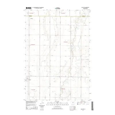
2015 Map of Mellette
USGS Topo · Published 2015About this map
The James River meanders across the eastern portion of this Spink County landscape, shaping the low-lying prairie topography of northeastern South Dakota. The settlement of Mellette serves as the primary hub, situated near the western edge along Sunshine Trl. The town's layout includes a centralized Po and access to local cemetery sites, notably Calvary Cem located to the north. To the north of Mellette lies Duxbury, another focal point for local history and settlement patterns in this agricultural region. The map reveals the intricate drainage system of the James River basin, including the tributary Mud Cr, which flows into the main river channel from the east. This survey documents the intersection of rural life and the river's path, where a strictly grid-based road network, including 387th Ave and 154th St, facilitates movement across the township lines of t120n r64w and t120n r63w.
Find a feature on this map
31 named features on this map. Tap any name to fly to it.
Don’t see what you’re looking for? This feature index may not catch every label — zoom into the map to look around manually.
Map Details
Editions of this 2015 Mellette Map
This is the sole edition of this map. No revisions or reprints were ever made.
Other maps of this area

1895 · Aberdeen
USGS Topo · 1:125,000

1899 · Northville
USGS Topo · 1:125,000

1953 · Brentford
USGS Topo · 1:24,000

1953 · Stratford
USGS Topo · 1:24,000

1953 · Gallup
USGS Topo · 1:24,000

1953 · Warner
USGS Topo · 1:24,000

1954 · Mellette
USGS Topo · 1:24,000

1954 · Aberdeen
USGS Topo · 1:250,000

1956 · Aberdeen
USGS Topo · 1:250,000
1960 · Brentford SE
USGS Topo · 1:24,000