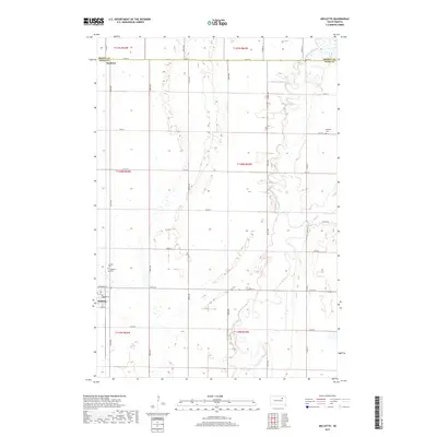
2017 Map of Mellette
USGS Topo · Published 2017About this map
The James River meanders through the heart of Spink County, defining the agricultural landscape of Mellette in the early 21st century. This survey documents a prairie region deeply rooted in its local heritage, evidenced by the clustered burial grounds near the main settlement, including Mellette Cem and Calvary Cem. To the north, the small community of Duxbury sits near the Brown County line, where the grid of sectional roads like Co Rd 27 and 387th Ave divides the sprawling fields.
Find a feature on this map
38 named features on this map. Tap any name to fly to it.
Don’t see what you’re looking for? This feature index may not catch every label — zoom into the map to look around manually.
Map Details
Editions of this 2017 Mellette Map
This is the sole edition of this map. No revisions or reprints were ever made.
Other maps of this area

1895 · Aberdeen
USGS Topo · 1:125,000

1899 · Northville
USGS Topo · 1:125,000

1953 · Brentford
USGS Topo · 1:24,000

1953 · Stratford
USGS Topo · 1:24,000

1953 · Gallup
USGS Topo · 1:24,000

1953 · Warner
USGS Topo · 1:24,000

1954 · Mellette
USGS Topo · 1:24,000

1954 · Aberdeen
USGS Topo · 1:250,000

1956 · Aberdeen
USGS Topo · 1:250,000
1960 · Brentford SE
USGS Topo · 1:24,000