
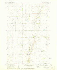
1954 Map of Mellette
USGS Topo · Published 1955About this map
The James River meanders heavily through the eastern reaches of this mid-century survey, defining the landscape between the townships of Rondell, Prairie, and Tetonka. The town of Mellette serves as the primary settlement, situated along the tracks of the Chicago Milwaukee St Paul and Pacific railroad and adjacent to Calvary Cem and the IOOF Cem.
Find a feature on this map
20 named features on this map. Tap any name to fly to it.
Don’t see what you’re looking for? This feature index may not catch every label — zoom into the map to look around manually.
Map Details
Editions of this 1954 Mellette Map
This is the sole edition of this map. No revisions or reprints were ever made.
Other maps of this area

1895 · Aberdeen
USGS Topo · 1:125,000

1899 · Northville
USGS Topo · 1:125,000

1953 · Brentford
USGS Topo · 1:24,000

1953 · Stratford
USGS Topo · 1:24,000

1953 · Gallup
USGS Topo · 1:24,000

1953 · Warner
USGS Topo · 1:24,000

1954 · Aberdeen
USGS Topo · 1:250,000

1956 · Aberdeen
USGS Topo · 1:250,000
1960 · Brentford SE
USGS Topo · 1:24,000

1960 · Rudolph
USGS Topo · 1:24,000