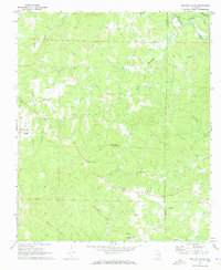
1969 Map of Mellow Valley
USGS Topo · Published 1973About this map
Mellow Valley and the surrounding rural communities of Clay and Randolph counties are defined by a complex network of creeks in this 1969 survey. The area is divided by the winding courses of Wesobulga Creek, Dinner Creek, and Hall Creek, which eventually feed into larger systems like Crooked Creek. Cultural life is anchored by small crossroads and country churches, including Corinth Ch, New Hope Ch, and Mt Olive Ch. The northeastern corner is clipped by the Seaboard Coast Line railroad near Cragford, while the southern landscape is characterized by more isolated terrain near the Blackjack Lookout Tower. The transition from larger settlements like Mellow Valley to scattered junctions like Cooley Crossroads and Almond suggests a landscape of small-scale agriculture and timber operations typical of this era in eastern Alabama.
Find a feature on this map
27 named features on this map. Tap any name to fly to it.
Don’t see what you’re looking for? This feature index may not catch every label — zoom into the map to look around manually.
Map Details
Editions of this 1969 Mellow Valley Map
2 editions found
Other maps of this area

1891 · Ashland
USGS Topo · 1:125,000

1953 · Atlanta
USGS Topo · 1:250,000

1957 · Atlanta
USGS Topo · 1:250,000

1958 · Atlanta
USGS Topo · 1:250,000

1969 · New Site
USGS Topo · 1:24,000

1969 · Wadley North
USGS Topo · 1:24,000

1969 · Gibsonville
USGS Topo · 1:24,000
1969 · Daviston
USGS Topo · 1:24,000
1969 · Wadley South
USGS Topo · 1:24,000

1969 · Mellow Valley
USGS Topo · 1:24,000