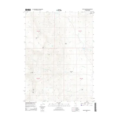
2014 Map of Melody Mountain
USGS Topo · Published 2014About this map
Melody Mtn and the surrounding high country of the Granite Range define this high-desert landscape in northern Washoe County. This 2014 survey documents a region defined by its vital water sources, from the isolated Melody Lake and Iveson Reservoir to numerous named springs like Chicken Spring and Warm Spring. The terrain is marked by significant topographical features such as Melody Rim, Melody Canyon, and the Hog Ranch Mountains, which influence the drainage patterns of several seasonal creeks. The presence of Wagon Tire Spring and Aspen Spring indicates the historical importance of localized water points for ranching and movement through this arid territory. The map provides a detailed record of the drainage networks for Negro Cr and Wagon Tire Cr, illustrating how these natural corridors intersect with the section lines of the Public Land Survey System.
Find a feature on this map
29 named features on this map. Tap any name to fly to it.
Don’t see what you’re looking for? This feature index may not catch every label — zoom into the map to look around manually.
Map Details
Editions of this 2014 Melody Mountain Map
This is the sole edition of this map. No revisions or reprints were ever made.
Other maps of this area

1886 · Granite Range
USGS Topo · 1:250,000

1889 · Long Valley
USGS Topo · 1:250,000

1894 · Granite Range
USGS Topo · 1:250,000

1954 · Vya
USGS Topo · 1:250,000

1955 · Lovelock
USGS Topo · 1:250,000

1958 · Vya
USGS Topo · 1:250,000

1959 · Lovelock
USGS Topo · 1:250,000

1962 · Vya
USGS Topo · 1:250,000

1980 · Melody Mountain
USGS Topo · 1:24,000
1980 · Fox Mountain
USGS Topo · 1:24,000