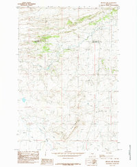
1985 Map of Melville NW
USGS Topo · Published 1985About this map
The Cayuse Hills dominate this mid-1980s Montana landscape, marking a rugged terrain of high ridges and deep drainages on the border of Wheatland and Sweet Grass counties. The area is defined by its water systems, primarily the eastward flow of Fish Creek, which is joined by tributaries including Sadie Creek and Cayuse Creek. These watercourses carve through the upland country, providing the fundamental structure for the few human imprints found in this ranching territory.
Find a feature on this map
9 named features on this map. Tap any name to fly to it.
Don’t see what you’re looking for? This feature index may not catch every label — zoom into the map to look around manually.
Map Details
Editions of this 1985 Melville NW Map
This is the sole edition of this map. No revisions or reprints were ever made.
Other maps of this area

1886 · Little Belt Mts.
USGS Topo · 1:250,000

1889 · Big Snowy Mountain
USGS Topo · 1:250,000

1893 · Big Snowy Mountain
USGS Topo · 1:250,000

1894 · Little Belt Mts.
USGS Topo · 1:250,000

1897 · Little Belt Mts.
USGS Topo · 1:250,000

1898 · Little Belt Mts.
USGS Topo · 1:250,000

1902 · Little Belt Mts.
USGS Topo · 1:250,000

1948 · White Sulphur Springs
USGS Topo · 1:250,000

1954 · Roundup
USGS Topo · 1:250,000

1958 · Roundup
USGS Topo · 1:250,000