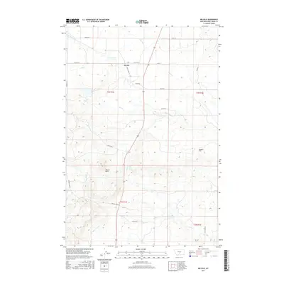
2017 Map of Melville
USGS Topo · Published 2017About this map
Melville serves as the central hub of this agricultural landscape in Sweet Grass County, where a network of gravel roads and state highways connects ranchlands along the eastern slopes of the Crazy Mountains. The settlement's layout is defined by Melville Main St and State Hwy 371, surrounded by a complex system of waterways. Significant water management is evident through the presence of the Big Timber Cr Canal, which moves water across the prairie to support local livestock and crops. To the south, the prominent Wheeler Butte rises above the terrain, while the Franklin Hills dominate the eastern reaches of the quadrangle. This 2017 survey details a region where the geography is dictated by drainages like Sweet Grass Cr, Otter Cr, and Wheeler Cr, illustrating the long-standing reliance on natural and engineered water sources in rural Montana.
Find a feature on this map
28 named features on this map. Tap any name to fly to it.
Don’t see what you’re looking for? This feature index may not catch every label — zoom into the map to look around manually.
Map Details
Editions of this 2017 Melville Map
This is the sole edition of this map. No revisions or reprints were ever made.
Other maps of this area

1886 · Little Belt Mts.
USGS Topo · 1:250,000

1889 · Big Snowy Mountain
USGS Topo · 1:250,000

1891 · Livingston
USGS Topo · 1:250,000

1891 · Big Timber
USGS Topo · 1:125,000

1893 · Livingston
USGS Topo · 1:250,000

1893 · Big Snowy Mountain
USGS Topo · 1:250,000

1893 · Big Timber
USGS Topo · 1:125,000

1894 · Little Belt Mts.
USGS Topo · 1:250,000

1897 · Little Belt Mts.
USGS Topo · 1:250,000

1898 · Little Belt Mts.
USGS Topo · 1:250,000