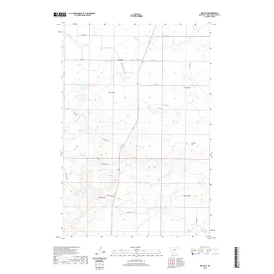
2020 Map of Melville
USGS Topo · Published 2020About this map
Melville serves as the central hub of this Sweet Grass County landscape, situated at the intersection of Melville Rd and State Hwy 371. The settlement's civic presence is anchored by its Po, while the surrounding terrain is defined by an extensive network of water management features designed to support agriculture in the eastern Montana foothills. The presence of the Upper Sweet Grass Canal, Lower Sweet Grass Canal, and Big Timber Cr Canal reveals a high-desert environment heavily modified by irrigation engineering. Natural landmarks such as Wheeler Butte and the Franklin Hills rise above the drainage systems of Sweet Grass Creek and Cayuse Cr, providing topographical context to the rural road network including Anderson Rd and Wheeler Creek Rd.
Find a feature on this map
31 named features on this map. Tap any name to fly to it.
Don’t see what you’re looking for? This feature index may not catch every label — zoom into the map to look around manually.
Map Details
Editions of this 2020 Melville Map
This is the sole edition of this map. No revisions or reprints were ever made.
Other maps of this area

1886 · Little Belt Mts.
USGS Topo · 1:250,000

1889 · Big Snowy Mountain
USGS Topo · 1:250,000

1891 · Livingston
USGS Topo · 1:250,000

1891 · Big Timber
USGS Topo · 1:125,000

1893 · Livingston
USGS Topo · 1:250,000

1893 · Big Snowy Mountain
USGS Topo · 1:250,000

1893 · Big Timber
USGS Topo · 1:125,000

1894 · Little Belt Mts.
USGS Topo · 1:250,000

1897 · Little Belt Mts.
USGS Topo · 1:250,000

1898 · Little Belt Mts.
USGS Topo · 1:250,000