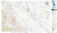
1982 Map of Mendota
USGS Topo · Published 1983About this map
The San Joaquin River and a complex network of man-made waterways define this Central Valley landscape in the early 1980s. Major agricultural and transit hubs like Mendota, Firebaugh, and Madera anchor a grid of irrigation infrastructure, including the Delta-Mendota Canal, California Aqueduct, and Eastside Bypass. This map captures the region's total transformation into a hydraulic powerhouse, where natural flows like Fresno Slough and Cottonwood Creek meet the engineering of the Main Canal and Outside Canal.
Find a feature on this map
54 named features on this map. Tap any name to fly to it.
Don’t see what you’re looking for? This feature index may not catch every label — zoom into the map to look around manually.
Map Details
Editions of this 1982 Mendota Map
2 editions found
Other maps of this area

1912 · Coalinga
USGS Topo · 1:125,000

1912 · Mariposa
USGS Topo · 1:125,000

1913 · Panoche
USGS Topo · 1:125,000

1915 · Priest Valley
USGS Topo · 1:125,000

1916 · Berenda
USGS Topo · 1:31,680

1916 · Santa Rita Bridge
USGS Topo · 1:24,000

1916 · Delta Ranch
USGS Topo · 1:24,000

1918 · Bliss Ranch
USGS Topo · 1:31,680

1918 · Chowchilla
USGS Topo · 1:31,680

1918 · Berenda
USGS Topo · 1:31,680