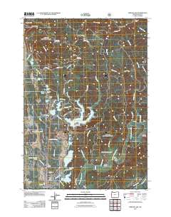
2011 Map of Mercer Lake
USGS Topo · Published 2011About this map
Florence serves as the coastal anchor for this landscape, where the North Fork Siuslaw River winds toward the Pacific through a complex network of coastal lakes and marshy lowlands. The geography is defined by a dense cluster of water bodies including Sutton Lake, Clear Lake, and the expansive, branching Mercer Lake, which is punctuated by the prominent Dowells Peninsula. This terrain reflects a transition from the sea-level flats of Three Mile Prairie to the interior heights of Cape Mountain and Herman Peak. Local infrastructure is sparse but specific to the area's timber and recreation history, featuring sites like Horse Creek Horse Camp and Alder Lake Camp. Genealogists and researchers may find interest in the Haring Cemetery located near the river, or the transitional settlement at Heceta Junction, while landmarks such as The Portage and Funke Bridge provide insight into how residents historically navigated this water-intersected corridor.
Find a feature on this map
78 named features on this map. Tap any name to fly to it.
Don’t see what you’re looking for? This feature index may not catch every label — zoom into the map to look around manually.
Map Details
Editions of this 2011 Mercer Lake Map
This is the sole edition of this map. No revisions or reprints were ever made.
Other maps of this area

1918 · Mapleton
USGS Topo · 1:48,000

1919 · Earl
USGS Topo · 1:48,000

1920 · Siltcoos Lake
USGS Topo · 1:62,500

1920 · Heceta Head
USGS Topo · 1:62,500

1940 · Mapleton
USGS Topo · 1:62,500

1941 · Siltcoos Lake
USGS Topo · 1:62,500

1942 · Heceta Head
USGS Topo · 1:62,500

1942 · Siltcoos Lake
USGS Topo · 1:62,500

1943 · Goodwin Peak
USGS Topo · 1:62,500

1945 · Mapleton
USGS Topo · 1:62,500