
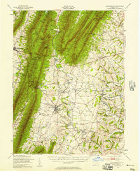
1943 Map of Mercersburg
USGS Topo · Published 1955About this map
The prominent Mercersburg Academy campus defines the local landscape of this mid-century Pennsylvania survey, situated just south of the Mercersburg Junction rail crossing. The town of Mercersburg serves as a hub for the surrounding rural valley, which is densely dotted with family-named one-room schools like Claylick Sch and Montpelier Sch. To the west, the formidable ridge of Tuscarora Mountain rises sharply, housing the Buchanan State Forest and the Big Mtn Lookout Tower at its heights. The map illustrates a landscape transitioning from the rugged ridges of the west to the limestone-rich valleys of the east, where subterranean features like Baker Caverns and early industrial sites such as Franklin Furnace and Millers Mill appear. Notable historical markers, including the Enoch Brown Memorial Park, underscore the deep colonial and frontier history of this portion of Franklin County.
Find a feature on this map
109 named features on this map. Tap any name to fly to it.
Don’t see what you’re looking for? This feature index may not catch every label — zoom into the map to look around manually.
Map Details
Editions of this 1943 Mercersburg Map
2 editions found
Other maps of this area

1899 · Hancock
USGS Topo · 1:62,500

1900 · Mercersburg
USGS Topo · 1:62,500

1901 · Hancock
USGS Topo · 1:62,500

1902 · Chambersburg
USGS Topo · 1:62,500

1902 · Mercersburg
USGS Topo · 1:62,500

1909 · Hagerstown
USGS Topo · 1:48,000

1912 · Hagerstown
USGS Topo · 1:62,500

1912 · Williamsport
USGS Topo · 1:62,500

1923 · Shippensburg
USGS Topo · 1:62,500

1925 · Needmore
USGS Topo · 1:48,000