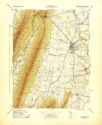
1944 Map of Mercersburg
USGS Topo · Published 1944About this map
Mercersburg serves as the focal point of this mid-1940s landscape, where the Mercersburg Academy and the prominent Mercersburg Reform Church Spire anchor the local community. The town is situated at a crossroads of transportation, where the Pennsylvania railroad line meets several regional routes. To the west, the steep rise of Tuscarora Mountain and Rattlesnake Ridge creates a natural barrier, much of which is preserved within the Buchanan State Forest and the Fulton Franklin Game Refuge.
Find a feature on this map
46 named features on this map. Tap any name to fly to it.
Don’t see what you’re looking for? This feature index may not catch every label — zoom into the map to look around manually.
Map Details
Editions of this 1944 Mercersburg Map
This is the sole edition of this map. No revisions or reprints were ever made.
Other maps of this area

1899 · Hancock
USGS Topo · 1:62,500

1900 · Mercersburg
USGS Topo · 1:62,500

1901 · Hancock
USGS Topo · 1:62,500

1902 · Mercersburg
USGS Topo · 1:62,500

1912 · Williamsport
USGS Topo · 1:62,500

1925 · Needmore
USGS Topo · 1:48,000

1935 · Needmore
USGS Topo · 1:62,500

1939 · Needmore
USGS Topo · 1:62,500

1942 · Hagerstown
USGS Topo · 1:125,000

1943 · Hagerstown
USGS Topo · 1:125,000