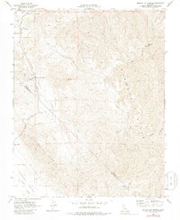
1969 Map of Mercey Hot Springs
USGS Topo · Published 1986About this map
Mercey Hot Springs anchors the northwestern corner of this landscape, positioned along the banks of Little Panoche Creek where it enters the broader Panoche Valley. This late-1960s survey captures a transition point in California’s coastal range, where the steep terrain of Panoche Mtn and the distinctively named Glaucophane Ridge overlook a network of specialized infrastructure. A Landing Strip and Radio Facility indicate the area's role in aviation or communication, while isolated Mine symbols and numerous jeep trails suggest continued exploration of the mineral-rich hills.
Find a feature on this map
21 named features on this map. Tap any name to fly to it.
Don’t see what you’re looking for? This feature index may not catch every label — zoom into the map to look around manually.
Map Details
Editions of this 1969 Mercey Hot Springs Map
2 editions found
Other maps of this area

1913 · Panoche
USGS Topo · 1:125,000

1921 · Laguna Seca Ranch
USGS Topo · 1:31,680

1921 · Tierra Loma School
USGS Topo · 1:31,680

1923 · Laguna Seca Ranch
USGS Topo · 1:31,680

1923 · Tierra Loma School
USGS Topo · 1:31,680

1923 · Little Panoche
USGS Topo · 1:31,680

1943 · Ortigalita Peak
USGS Topo · 1:62,500

1944 · Panoche Valley
USGS Topo · 1:62,500

1948 · Santa Cruz
USGS Topo · 1:250,000

1955 · Santa Cruz
USGS Topo · 1:250,000