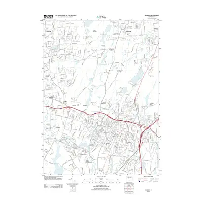
2012 Map of Meriden
USGS Topo · Published 2012About this map
Ragged Mountain and the Hanging Hills dominate the skyline of this central Connecticut landscape, framing a dense network of suburban growth and industrial heritage. The corridor is defined by the Quinnipiac River, which winds south toward Hanover Pond and the Quinnipiac Gorge. For genealogists and local historians, the sheet is exceptionally rich in burial data, preserving the locations of the Burying Ground 1720 and the South Burying Ground, alongside more modern sites like the Meriden Hebrew Cem and Gethsemane Cem. The map illustrates the convergence of major infrastructure, from the Amtrak line to the intersection of I-91 and I-691, while also highlighting community landmarks such as the Miller Memorial Community and the Kensington Atlantic State Fishing Hatchery. From the heights of West Peak to the residential streets of South Meriden, the document captures a complex urban-wildland interface.
Find a feature on this map
87 named features on this map. Tap any name to fly to it.
Don’t see what you’re looking for? This feature index may not catch every label — zoom into the map to look around manually.
Map Details
Editions of this 2012 Meriden Map
This is the sole edition of this map. No revisions or reprints were ever made.
Other maps of this area

1892 · New Haven
USGS Topo · 1:62,500

1892 · Meriden
USGS Topo · 1:62,500

1893 · Guilford
USGS Topo · 1:62,500

1893 · Middletown
USGS Topo · 1:62,500

1893 · Meriden
USGS Topo · 1:62,500

1906 · Farmington
USGS Topo · 1:125,000

1921 · New Haven
USGS Topo · 1:62,500

1928 · Cromwell
USGS Topo · 1:24,000

1943 · Durham
USGS Topo · 1:25,000

1944 · Hartford South
USGS Topo · 1:31,680