
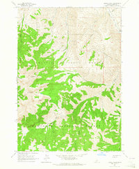
2013 Map of Meridian Peak
USGS Topo · Published 2013About this map
Meridian Peak stands as a central geographic anchor where the boundaries of the Sawtooth National Forest and Challis National Forest meet in this high-elevation region of Idaho. The landscape is defined by a dense network of drainages and named summits, including the prominent Hunter Creek Summit to the west. This survey illustrates the intricate watershed of the N Fork Big Lost River, which is fed by numerous tributaries such as Bear Cr and Blind Cr.
Find a feature on this map
29 named features on this map. Tap any name to fly to it.
Don’t see what you’re looking for? This feature index may not catch every label — zoom into the map to look around manually.
Map Details
Editions of this 2013 Meridian Peak Map
This is the sole edition of this map. No revisions or reprints were ever made.
Other maps of this area

1895 · Hailey
USGS Topo · 1:125,000

1897 · Hailey
USGS Topo · 1:125,000

1929 · Bayhorse
USGS Topo · 1:125,000

1955 · Hailey
USGS Topo · 1:250,000

1957 · Challis
USGS Topo · 1:250,000

1959 · Hailey
USGS Topo · 1:250,000

1960 · Challis
USGS Topo · 1:250,000

1962 · Hailey
USGS Topo · 1:250,000

1963 · Challis
USGS Topo · 1:250,000
1963 · Bowery Peak
USGS Topo · 1:24,000