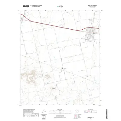
2019 Map of Merkel West
USGS Topo · Published 2019About this map
Merkel and the nearby community of Blair sit at the edge of the high plains, where the land begins to break into the prominent relief of Mulberry Canyon. This landscape is defined by its seasonal watercourses and distinctive mesas, including the prominent heights of Blowout Mtn and Spears Mtn. To the northwest, the town of Trent marks another hub of settlement along the interstate corridor. Genealogy researchers will find significant value in the detailed plotting of Trent Cem and Rose Hill Cem, which serve these rural Texas communities. The drainage patterns of Little Bitter Cr and Noodle Cr illustrate the natural topography that historically dictated the placement of ranch roads and early settlements. This 2019 survey captures the modern road network, from major arteries like FM 126 to local paths such as 12 Mile Rd and Derstine Rd, documenting the contemporary rural infrastructure of Taylor County.
Find a feature on this map
101 named features on this map. Tap any name to fly to it.
Don’t see what you’re looking for? This feature index may not catch every label — zoom into the map to look around manually.
Map Details
Editions of this 2019 Merkel West Map
This is the sole edition of this map. No revisions or reprints were ever made.
Other maps of this area

1890 · Abilene
USGS Topo · 1:125,000

1891 · Anson
USGS Topo · 1:125,000

1892 · Abilene
USGS Topo · 1:125,000

1893 · Roby
USGS Topo · 1:125,000

1893 · Anson
USGS Topo · 1:125,000

1893 · Sweetwater
USGS Topo · 1:125,000

1954 · Big Spring
USGS Topo · 1:250,000

1954 · Abilene
USGS Topo · 1:250,000

1957 · Hawley
USGS Topo · 1:62,500

1957 · Merkel
USGS Topo · 1:62,500