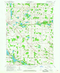
1965 Map of Merriam
USGS Topo · Published 1966About this map
Glacial lakes dominate this mid-century landscape of Noble and Whitley counties, where the newly established Chain O'Lakes State Park encompasses a dense cluster of interconnected water bodies like Sand Lake and Bowen Lake. The small settlement of Merriam serves as a local crossroads, supported by community fixtures such as the Merriam Chapel and Merriam Cemetery. Along the banks of Crooked Lake, the Indiana University Biological Station underscores the scientific importance of this freshwater ecosystem. Further north, the landscape transitions into agricultural plots and scattered residential clusters at Wolflake and Port Mitchell. This 1965 revision captures the region as leisure and conservation efforts began to shape the land around traditional farming communities, noted by the presence of the Crooked Lake Golf Club and a local Landing Strip.
Find a feature on this map
76 named features on this map. Tap any name to fly to it.
Don’t see what you’re looking for? This feature index may not catch every label — zoom into the map to look around manually.
Map Details
Editions of this 1965 Merriam Map
This is the sole edition of this map. No revisions or reprints were ever made.
Other maps of this area

1951 · Ormas
USGS Topo · 1:24,000

1951 · Merriam
USGS Topo · 1:24,000

1953 · Fort Wayne
USGS Topo · 1:250,000

1955 · Columbia City
USGS Topo · 1:24,000

1955 · Ege
USGS Topo · 1:24,000

1955 · Kendallville
USGS Topo · 1:24,000

1956 · Fort Wayne
USGS Topo · 1:250,000

1956 · Ligonier
USGS Topo · 1:24,000

1956 · Lorane
USGS Topo · 1:24,000

1956 · Albion
USGS Topo · 1:24,000