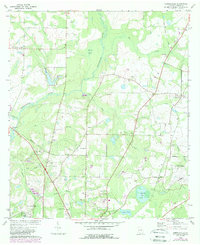
1975 Map of Merrillville
USGS Topo · Published 1986About this map
The Ochlocknee River meanders through Thomas County, defining a landscape of wetlands and small rural settlements in the mid-1970s. This area is characterized by a dense network of country churches, including Midway Ch, St Pauls Ch, and Beulah Hill Ch, which served as the social anchors for scattered communities like Merrillville and Paseo. The presence of the Thomasville Municipal Airport in the southeast and the Confederate Bridge to the west suggests a mix of modern infrastructure and local memory along the riverbanks.
Find a feature on this map
38 named features on this map. Tap any name to fly to it.
Don’t see what you’re looking for? This feature index may not catch every label — zoom into the map to look around manually.
Map Details
Editions of this 1975 Merrillville Map
This is the sole edition of this map. No revisions or reprints were ever made.
Other maps of this area

1953 · Dothan
USGS Topo · 1:250,000

1953 · Waycross
USGS Topo · 1:250,000

1954 · Dothan
USGS Topo · 1:250,000

1954 · Valdosta
USGS Topo · 1:250,000

1954 · Tallahassee
USGS Topo · 1:250,000

1955 · Dothan
USGS Topo · 1:250,000

1956 · Cairo
USGS Topo · 1:62,500

1957 · Thomasville
USGS Topo · 1:62,500

1958 · Valdosta
USGS Topo · 1:250,000

1958 · Waycross
USGS Topo · 1:250,000