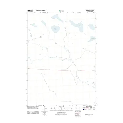
2011 Map of Merriman NE
USGS Topo · Published 2011About this map
Steve Moreland Ranch and Bob Moreland Ranch anchor a landscape defined by expansive cattle operations and scattered water bodies along the Nebraska-South Dakota border. The northern reaches are dotted with prominent basins including Goose Lake, S B Lake, and the aptly named Clubhouse Lake. This 2011 survey reflects the enduring rural character of the region, where family-named properties like Quible Ranch, Schlack Ranch, and Wickman Ranch serve as primary landmarks across the high plains.
Find a feature on this map
12 named features on this map. Tap any name to fly to it.
Don’t see what you’re looking for? This feature index may not catch every label — zoom into the map to look around manually.
Map Details
Editions of this 2011 Merriman NE Map
This is the sole edition of this map. No revisions or reprints were ever made.
Other maps of this area

1951 · Merriman
USGS Topo · 1:62,500

1952 · Eli
USGS Topo · 1:62,500

1955 · Martin
USGS Topo · 1:250,000

1957 · Valentine
USGS Topo · 1:250,000

1958 · Martin
USGS Topo · 1:250,000

1959 · Valentine
USGS Topo · 1:250,000

1981 · Phantom Lake
USGS Topo · 1:25,000

1981 · Scotchman Lake
USGS Topo · 1:25,000

1983 · Martin
USGS Topo · 1:100,000
1985 · Eli
USGS Topo · 1:24,000