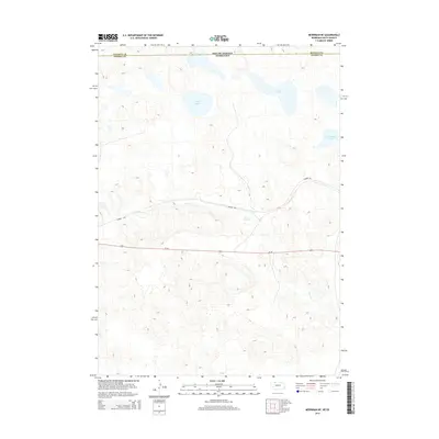
2014 Map of Merriman NE
USGS Topo · Published 2014About this map
South Dakota and Nebraska meet along this 2014 survey of the sandhills borderland, where the terrain is defined by a series of significant lakes and drainage patterns. The northern reaches of the map feature several distinct bodies of water, including Goose Lake, S B Lake, and Clubhouse Lake, which sit amidst the undulating topography. Bear Cr meanders across the central landscape, cutting through the elevation contours before heading southeast. Transportation corridors are clearly defined by the path of Us-20 and the Cowboy Trl, showing how modern and recreational infrastructure follow the natural valley floor created by the creek. This map provides a clear record of the hydrological and boundary lines where Bennett County and Cherry County intersect at the state line.
Find a feature on this map
8 named features on this map. Tap any name to fly to it.
Don’t see what you’re looking for? This feature index may not catch every label — zoom into the map to look around manually.
Map Details
Editions of this 2014 Merriman NE Map
This is the sole edition of this map. No revisions or reprints were ever made.
Other maps of this area

1951 · Merriman
USGS Topo · 1:62,500

1952 · Eli
USGS Topo · 1:62,500

1955 · Martin
USGS Topo · 1:250,000

1957 · Valentine
USGS Topo · 1:250,000

1958 · Martin
USGS Topo · 1:250,000

1959 · Valentine
USGS Topo · 1:250,000

1981 · Phantom Lake
USGS Topo · 1:25,000

1981 · Scotchman Lake
USGS Topo · 1:25,000

1983 · Martin
USGS Topo · 1:100,000
1985 · Eli
USGS Topo · 1:24,000