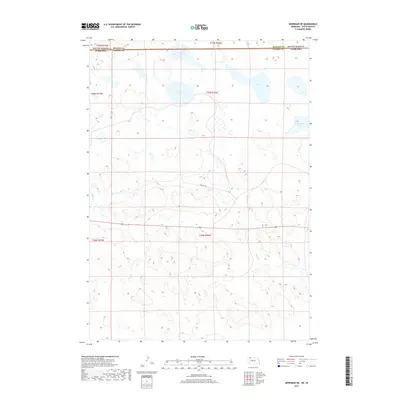
2017 Map of Merriman NE
USGS Topo · Published 2017About this map
The state boundary between South Dakota and Nebraska bisects this landscape, separating Bennett County and Cherry County. The terrain is defined by a series of significant water bodies including Goose Lake, S B Lake, and Clubhouse Lake. These features, along with the meandering course of Bear Creek, illustrate the hydrologic character of this border region. The presence of the Cowboy Trl crossing the central section follows a historic transportation corridor, suggesting a legacy of movement through this sparsely populated ranching country. The map's detailed township and range lines, such as t35n r36w, provide a foundational grid for researchers tracing specific land parcels and historical property boundaries in the northern High Plains.
Find a feature on this map
11 named features on this map. Tap any name to fly to it.
Don’t see what you’re looking for? This feature index may not catch every label — zoom into the map to look around manually.
Map Details
Editions of this 2017 Merriman NE Map
This is the sole edition of this map. No revisions or reprints were ever made.
Other maps of this area

1951 · Merriman
USGS Topo · 1:62,500

1952 · Eli
USGS Topo · 1:62,500

1955 · Martin
USGS Topo · 1:250,000

1957 · Valentine
USGS Topo · 1:250,000

1958 · Martin
USGS Topo · 1:250,000

1959 · Valentine
USGS Topo · 1:250,000

1981 · Phantom Lake
USGS Topo · 1:25,000

1981 · Scotchman Lake
USGS Topo · 1:25,000

1983 · Martin
USGS Topo · 1:100,000
1985 · Eli
USGS Topo · 1:24,000