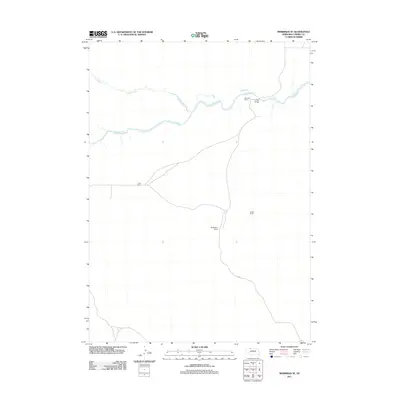
2011 Map of Merriman SE
USGS Topo · Published 2011About this map
The Niobrara River winds through this section of Cherry County, defining a landscape shaped by large-scale ranching and remote Nebraska sandhills drainage. Family-named outposts like Simmons Ranch and McGaughey Ranch serve as primary landmarks in an area where the human footprint is centered on grazing lands and a sparse network of unpaved roads. The convergence of Leander Creek into the Niobrara highlights the importance of water sources in this semi-arid region. Connectivity is maintained through specific crossing points such as Crane Bridge and local routes like Eli Rd, which link the various spreads, including Cobb Ranch and Yeager Ranch, to the wider county. This survey preserves the ranching boundaries and water systems essential to the local agricultural economy at the start of the decade.
Find a feature on this map
8 named features on this map. Tap any name to fly to it.
Don’t see what you’re looking for? This feature index may not catch every label — zoom into the map to look around manually.
Map Details
Editions of this 2011 Merriman SE Map
This is the sole edition of this map. No revisions or reprints were ever made.
Other maps of this area

1950 · Doughboy
USGS Topo · 1:62,500

1951 · Merriman
USGS Topo · 1:62,500

1951 · Merriman 4
USGS Topo · 1:62,500

1952 · Eli
USGS Topo · 1:62,500

1952 · Doughboy
USGS Topo · 1:62,500

1957 · Valentine
USGS Topo · 1:250,000

1959 · Valentine
USGS Topo · 1:250,000
1985 · Eli
USGS Topo · 1:24,000

1985 · Cody
USGS Topo · 1:100,000
1985 · Eli SW
USGS Topo · 1:24,000