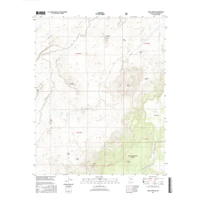
2017 Map of Mesa Cortada
USGS Topo · Published 2017About this map
Cibola National Forest defines the southern portion of this McKinley County landscape, where the high-altitude terrain is marked by prominent volcanic and sedimentary formations. The Continental Divide National Scenic Trail traverses the eastern sections, winding past the heights of Cerro Colorado and through the drainage of Arroyo Seccion. A complex network of ephemeral water sources and livestock tanks, such as Gonzolas Tank and Rincon Grande Tank, underscores the importance of water management in this arid environment. Significant landforms like San Miguel Creek Dome and Mesa Cortada rise above the surrounding canyons, including Los Indios Canyon and Chavez Canyon. The mapping of small springs like Ojo Navajo and Ojo de los Indios indicates a long-standing human reliance on localized water points throughout this high-desert region.
Find a feature on this map
32 named features on this map. Tap any name to fly to it.
Don’t see what you’re looking for? This feature index may not catch every label — zoom into the map to look around manually.
Map Details
Editions of this 2017 Mesa Cortada Map
This is the sole edition of this map. No revisions or reprints were ever made.
Other maps of this area

1883 · Mt. Taylor
USGS Topo · 1:250,000

1886 · Mt. Taylor
USGS Topo · 1:250,000

1892 · Mt. Taylor
USGS Topo · 1:250,000

1899 · Mt. Taylor
USGS Topo · 1:250,000

1958 · Albuquerque
USGS Topo · 1:250,000

1961 · El Dado
USGS Topo · 1:24,000

1961 · Cerro Parido
USGS Topo · 1:24,000

1961 · El Dado Mesa
USGS Topo · 1:24,000

1961 · Mesita Del Gavilan
USGS Topo · 1:24,000
1961 · Mesita Americana
USGS Topo · 1:24,000