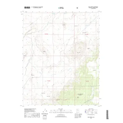
2020 Map of Mesa Cortada
USGS Topo · Published 2020About this map
The high desert landscape of McKinley County is defined by prominent geological formations like San Miguel Creek Dome and the plateau of Mesa Cortada. This 2020 survey of the high mesas and arroyos shows a region structured by water management and topography. Numerous named stock tanks, such as Gonzolas Tank, Candido Tank, and Rincon Grande Tank, emphasize the importance of water sources in this arid environment. The southern portion of the map includes a section of the Cibola National Forest, where elevations rise toward Cerro Chavez and Cerro Colorado. Notable transit markers include Indian Rte 7078 and the Continental Divide National Scenic Trail, which winds through the eastern ridges. Historic place-names like Ojo Navajo and Ojo de los Indios indicate long-standing springs used by travelers and residents of the San Juan Basin.
Find a feature on this map
33 named features on this map. Tap any name to fly to it.
Don’t see what you’re looking for? This feature index may not catch every label — zoom into the map to look around manually.
Map Details
Editions of this 2020 Mesa Cortada Map
This is the sole edition of this map. No revisions or reprints were ever made.
Other maps of this area

1883 · Mt. Taylor
USGS Topo · 1:250,000

1886 · Mt. Taylor
USGS Topo · 1:250,000

1892 · Mt. Taylor
USGS Topo · 1:250,000

1899 · Mt. Taylor
USGS Topo · 1:250,000

1958 · Albuquerque
USGS Topo · 1:250,000

1961 · El Dado
USGS Topo · 1:24,000

1961 · Cerro Parido
USGS Topo · 1:24,000

1961 · El Dado Mesa
USGS Topo · 1:24,000

1961 · Mesita Del Gavilan
USGS Topo · 1:24,000
1961 · Mesita Americana
USGS Topo · 1:24,000