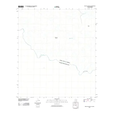
2010 Map of Mesa De Anguila
USGS Topo · Published 2010About this map
The Rio Grande serves as the prominent natural and political boundary in this borderlands survey, defining the divide between the United States of America and Estados Unidos Mexicanos. The landscape is dominated by the massive Mesa de Anguila, an elevated plateau that dictates the local drainage patterns toward the river. Within this arid terrain, localized water sources like Tinaja Grande and Well Creek represent critical landmarks for navigation and survival. To the southeast, the river carves through the dramatic Santa Elena Canyon, while the sharp peak of Sierra Aguja rises to the north. This map captures the stark, unpopulated nature of the Big Bend region, where topographic relief and the international waterway are the primary features of the land.
Find a feature on this map
8 named features on this map. Tap any name to fly to it.
Don’t see what you’re looking for? This feature index may not catch every label — zoom into the map to look around manually.
Map Details
Editions of this 2010 Mesa De Anguila Map
This is the sole edition of this map. No revisions or reprints were ever made.
Other maps of this area

1903 · Terlingua
USGS Topo · 1:125,000

1904 · Terlingua
USGS Topo · 1:125,000

1931 · Lajitas
USGS Topo · 1:62,500

1959 · Emory Peak
USGS Topo · 1:250,000

1965 · Emory Peak
USGS Topo · 1:250,000

1971 · Terlingua
USGS Topo · 1:24,000

1971 · Amarilla Mountain
USGS Topo · 1:24,000
1971 · Castolon
USGS Topo · 1:24,000
1971 · Lajitas
USGS Topo · 1:24,000
1971 · Mesa De Anguila
USGS Topo · 1:24,000