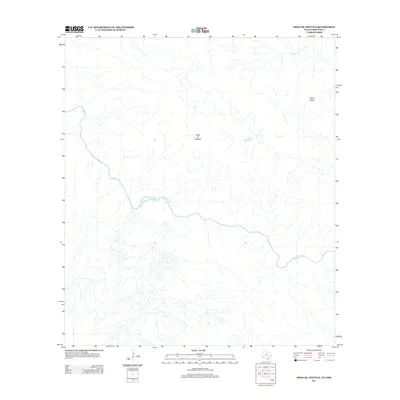
2012 Map of Mesa De Anguila
USGS Topo · Published 2012About this map
The Rio Grande carves a deep path through this trans-border landscape, defining the international boundary between Texas and Mexico. The dramatic elevation changes of the Mesa de Anguila dominate the central terrain, while the peaks of Sierra Aguja rise to the northeast. This 2012 survey illustrates a sparse, arid environment where water sources are vital geographic anchors, notably Tinaja Grande and Well Cr. The map captures the complex drainage patterns of seasonal washes and arroyos that feed into the primary river system, reflecting the hydrologic reality of the Big Bend region. Because there are no roads or settlements printed on this quadrangle, the focus remains entirely on the natural landforms and the water-carved topography of the high desert borderlands.
Find a feature on this map
5 named features on this map. Tap any name to fly to it.
Don’t see what you’re looking for? This feature index may not catch every label — zoom into the map to look around manually.
Map Details
Editions of this 2012 Mesa De Anguila Map
This is the sole edition of this map. No revisions or reprints were ever made.
Other maps of this area

1903 · Terlingua
USGS Topo · 1:125,000

1904 · Terlingua
USGS Topo · 1:125,000

1931 · Lajitas
USGS Topo · 1:62,500

1959 · Emory Peak
USGS Topo · 1:250,000

1965 · Emory Peak
USGS Topo · 1:250,000

1971 · Terlingua
USGS Topo · 1:24,000

1971 · Amarilla Mountain
USGS Topo · 1:24,000
1971 · Castolon
USGS Topo · 1:24,000
1971 · Lajitas
USGS Topo · 1:24,000
1971 · Mesa De Anguila
USGS Topo · 1:24,000