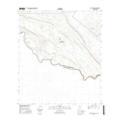
2016 Map of Mesa De Anguila
USGS Topo · Published 2016About this map
Santa Elena Canyon serves as a dramatic centerpiece along the international boundary where the Rio Grande carves through the limestone of the Chihuahuan Desert. This remote sector of Big Bend National Park is defined by the high, flat-topped Mesa de Anguila, which rises sharply from the riverbank in Brewster County. The map reveals the intricate drainage patterns and relief of the Trans-Pecos, including isolated peaks such as Sierra Aguja and specialized desert water features like Tinaja Blanca and Tinaja Rana Tinaja Grande. These natural tanks and canyons emphasize the vital role of water in an arid landscape, marking the intersection of Texas and the Estados Unidos Mexicanos.
Find a feature on this map
12 named features on this map. Tap any name to fly to it.
Don’t see what you’re looking for? This feature index may not catch every label — zoom into the map to look around manually.
Map Details
Editions of this 2016 Mesa De Anguila Map
This is the sole edition of this map. No revisions or reprints were ever made.
Other maps of this area

1903 · Terlingua
USGS Topo · 1:125,000

1904 · Terlingua
USGS Topo · 1:125,000

1931 · Lajitas
USGS Topo · 1:62,500

1959 · Emory Peak
USGS Topo · 1:250,000

1965 · Emory Peak
USGS Topo · 1:250,000

1971 · Terlingua
USGS Topo · 1:24,000

1971 · Amarilla Mountain
USGS Topo · 1:24,000
1971 · Castolon
USGS Topo · 1:24,000
1971 · Lajitas
USGS Topo · 1:24,000
1971 · Mesa De Anguila
USGS Topo · 1:24,000