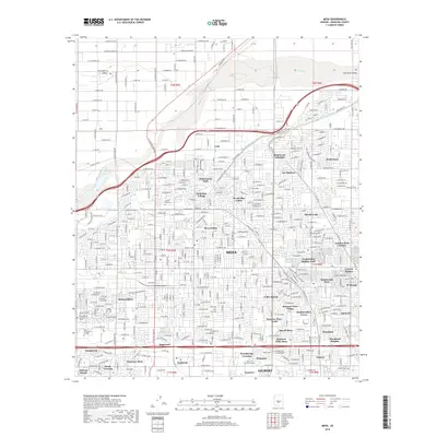
2018 Map of Mesa
USGS Topo · Published 2018About this map
The Salt River valley landscape of Mesa is defined here by a dense grid of residential developments and irrigation infrastructure. Major water works like the Consolidated Canal and the Southern Canal cut across the city, tracing the historical agricultural layout that paved the way for modern suburban expansion. Neighborhoods such as Hohokam Village, Lehi, and Rancho de Arboleda are documented alongside established institutions including Mesa Community College and the Pima Medical Institute. Researchers will find significant genealogical sites like the City Of Mesa Cem and Queen of Heaven Cem in the southern reaches near McQueen. The presence of the 202 and 60 freeways highlights the era's transportation network, which connects numerous planned communities like Woodridge Lakes and Summer Place Village within the township boundaries of t1n r5e and t1n r6e.
Find a feature on this map
56 named features on this map. Tap any name to fly to it.
Don’t see what you’re looking for? This feature index may not catch every label — zoom into the map to look around manually.
Map Details
Editions of this 2018 Mesa Map
This is the sole edition of this map. No revisions or reprints were ever made.
Other maps of this area

1904 · Camelback
USGS Topo · 1:62,500

1904 · Desert Well
USGS Topo · 1:62,500

1904 · Ft. McDowell
USGS Topo · 1:62,500

1906 · Camelsback
USGS Topo · 1:62,500

1906 · Ft. McDowell
USGS Topo · 1:62,500

1906 · Desert Well
USGS Topo · 1:62,500

1913 · Mesa
USGS Topo · 1:62,500

1915 · Mesa
USGS Topo · 1:62,500

1930 · Cave Creek
USGS Topo · 1:125,000

1939 · Cave Creek
USGS Topo · 1:125,000