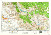
1964 Map of Mesa
USGS Topo · Published 1964About this map
The Phoenix metropolitan area and the rugged copper corridor of central Arizona appear here during a period of significant mid-century transition. While the valley floor shows the growing footprints of Tempe, Mesa, and Chandler, much of the surrounding landscape remains dominated by massive land withdrawals and industrial operations. The industrial heart of the region is centered on the copper mines of the Gila Mountains and Pinal Mountains, including the Miami Mine, Inspiration Mine, and Magma Mine. These operations, alongside the Ray Mine, underscore the mining economy that defined towns like Superior and Globe.
Find a feature on this map
193 named features on this map. Tap any name to fly to it.
Don’t see what you’re looking for? This feature index may not catch every label — zoom into the map to look around manually.
Map Details
Editions of this 1964 Mesa Map
This is the sole edition of this map. No revisions or reprints were ever made.
Other maps of this area

1886 · St Johns
USGS Topo · 1:250,000
1886 · Holbrook
USGS Topo · 1:250,000

1887 · Verde
USGS Topo · 1:250,000

1887 · Prescott
USGS Topo · 1:250,000

1892 · Verde
USGS Topo · 1:250,000
1892 · St Johns
USGS Topo · 1:250,000
1892 · Prescott
USGS Topo · 1:250,000
1893 · Holbrook
USGS Topo · 1:250,000
1900 · Florence
USGS Topo · 1:125,000
1901 · Globe
USGS Topo · 1:62,500