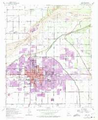
1972 Map of Mesa
USGS Topo · Published 1975About this map
The Salt River corridor and the expanding urban core of Mesa define this desert landscape during a period of rapid mid-century growth. North of the river, the Salt River Indian Reservation remains largely undeveloped, containing the Salt River Indian Day Sch and the Salt River Reservation Clinic. To the south, the city is meticulously organized by a grid of major thoroughfares like Country Club Drive and Main Street, with irrigation infrastructure such as the Consolidated Canal and Tempe Canal still visible amongst new residential subdivisions. The map captures an era of educational and civic investment, featuring the landmark LDS Temple, Mesa Community College, and numerous neighborhood schools like Irving Sch and Franklin Sch. This survey serves as a vital record of the transition from an agricultural river valley into a major metropolitan center.
Find a feature on this map
51 named features on this map. Tap any name to fly to it.
Don’t see what you’re looking for? This feature index may not catch every label — zoom into the map to look around manually.
Map Details
Editions of this 1972 Mesa Map
This is the sole edition of this map. No revisions or reprints were ever made.
Other maps of this area

1904 · Camelback
USGS Topo · 1:62,500

1904 · Desert Well
USGS Topo · 1:62,500

1904 · Ft. McDowell
USGS Topo · 1:62,500

1906 · Camelsback
USGS Topo · 1:62,500

1906 · Ft. McDowell
USGS Topo · 1:62,500

1906 · Desert Well
USGS Topo · 1:62,500

1913 · Mesa
USGS Topo · 1:62,500

1915 · Mesa
USGS Topo · 1:62,500

1930 · Cave Creek
USGS Topo · 1:125,000

1939 · Cave Creek
USGS Topo · 1:125,000