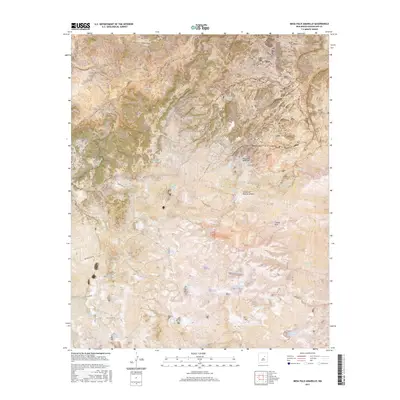
2017 Map of Mesa Palo Amarillo
USGS Topo · Published 2017About this map
Mesa Palo Amarillo dominates this High Plains landscape in Guadalupe County, where a complex network of seasonal water catchments supports the high-desert environment. This 2017 survey details a land defined by its arroyo systems and named canyons, including Cañon Blanco and Cañon de Rancho Alegre. The terrain is characterized by broad mesas like La Mesa Del Medio and scattered lowland features such as Red Lake and Laguna Quates. The density of named livestock tanks and traps, such as Bills Tank, Starve-Out Trap, and Secundino Tank, reflects a ranching economy where water management is the primary shaper of human activity. A grid of local roads and trails, including Palo Amarillo Rd, Tierra Blanca RD, and Penderson TRL, connects these remote water points across the plains, following the natural contours of the drainages and mesa edges.
Find a feature on this map
38 named features on this map. Tap any name to fly to it.
Don’t see what you’re looking for? This feature index may not catch every label — zoom into the map to look around manually.
Map Details
Editions of this 2017 Mesa Palo Amarillo Map
This is the sole edition of this map. No revisions or reprints were ever made.
Other maps of this area

1890 · Bernal
USGS Topo · 1:125,000

1891 · Bernal
USGS Topo · 1:125,000

1894 · Bernal
USGS Topo · 1:125,000

1954 · Santa Fe
USGS Topo · 1:250,000

1954 · Fort Sumner
USGS Topo · 1:250,000

1958 · Fort Sumner
USGS Topo · 1:250,000

1958 · Santa Fe
USGS Topo · 1:250,000
1963 · Thompson Ranch
USGS Topo · 1:24,000
1963 · Anton Chico
USGS Topo · 1:24,000
1963 · Mesa Palo Amarillo
USGS Topo · 1:24,000