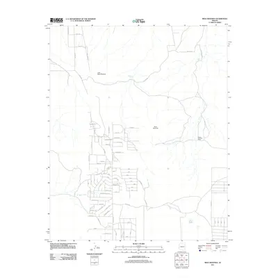
2011 Map of Mesa Redonda
USGS Topo · Published 2011About this map
Mesa Redonda and its smaller counterpart, Little Mesa Redonda, define the elevated topography of this Navajo County landscape. The 2011 survey reveals a complex network of residential roads branching off thoroughfares like Stanford Dr and Co Rd 8283, indicating significant rural development in the southern portion of the quadrangle. This infrastructure is interspersed with essential water management features such as Martinez Tank and Red Rock Tank, which are critical in this arid Arizona environment.
Find a feature on this map
79 named features on this map. Tap any name to fly to it.
Don’t see what you’re looking for? This feature index may not catch every label — zoom into the map to look around manually.
Map Details
Editions of this 2011 Mesa Redonda Map
This is the sole edition of this map. No revisions or reprints were ever made.
Other maps of this area

1886 · St Johns
USGS Topo · 1:250,000

1892 · St Johns
USGS Topo · 1:250,000

1954 · Saint Johns
USGS Topo · 1:250,000

1955 · Adamana 4 SW
USGS Topo · 1:24,000

1955 · Adamana 3 SE
USGS Topo · 1:24,000

1955 · Hunt
USGS Topo · 1:62,500

1957 · Saint Johns
USGS Topo · 1:250,000

1958 · Saint Johns
USGS Topo · 1:250,000

1962 · Saint Johns
USGS Topo · 1:250,000
1971 · Vernon
USGS Topo · 1:24,000