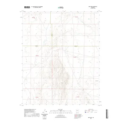
2020 Map of Mesa Sarca
USGS Topo · Published 2020About this map
Mesa Sarca rises as a prominent high-desert landform at the intersection of three New Mexico counties, where the high-altitude terrain is carved by complex drainage systems. The landscape is defined by its arid hydrology, featuring water sources such as Ojo Saladito and intermittent catchments like Rock Tank and Middle Tank. This 2020 survey documents a transition zone where the borders of Cibola, Valencia, and Socorro counties meet, revealing a remote territory dominated by winding watercourses. Significant natural channels, including Arroyo Pato, Arroyo Monte Largo, and Coyote Draw, illustrate the erosional patterns that have shaped the plateau over generations. The map provides a precise look at the township and range divisions, such as t4n r3w and t4n r4w, that organize this largely uninhabited portion of the state.
Find a feature on this map
16 named features on this map. Tap any name to fly to it.
Don’t see what you’re looking for? This feature index may not catch every label — zoom into the map to look around manually.
Map Details
Editions of this 2020 Mesa Sarca Map
This is the sole edition of this map. No revisions or reprints were ever made.
Other maps of this area

1917 · Cerro Verde
USGS Topo · 1:125,000

1954 · Socorro
USGS Topo · 1:250,000

1956 · Mesa Aparejo
USGS Topo · 1:62,500

1958 · Socorro
USGS Topo · 1:250,000

1959 · Riley
USGS Topo · 1:62,500

1962 · Socorro
USGS Topo · 1:250,000

1964 · La Jara Peak
USGS Topo · 1:24,000
1964 · Chicken Mountain
USGS Topo · 1:24,000
1964 · Puerto De Los Cavadores
USGS Topo · 1:24,000
1978 · Acoma Pueblo
USGS Topo · 1:100,000