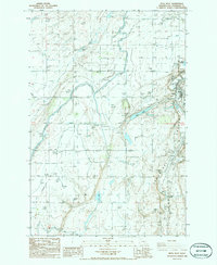
1986 Map of Mesa West
USGS Topo · Published 1986About this map
Mesa and the smaller locality of Edwards anchor this mid-1980s landscape, where the intensive water management of the Columbia Basin Project is on full display. The terrain is defined by a complex network of irrigation infrastructure, including a Siphon, Spillway, and Aqueduct that service the surrounding agricultural tracts. Large Spoil Banks and a Levee system trace the movement of earth and water through the coulees. Natural and man-made water bodies like Mesa Lake, Worth Lake, and Clark Pond punctuate the arid surroundings, reflecting the transformation of the region's hydrology. Transportation and logistics are central to the area's layout, with the Burlington Northern railroad running parallel to an Old RR Grade and several gravel operations. The presence of numerous storage bins and pumping stations underscores the industrial scale of local farming operations as they existed during this era of Franklin County's development.
Find a feature on this map
22 named features on this map. Tap any name to fly to it.
Don’t see what you’re looking for? This feature index may not catch every label — zoom into the map to look around manually.
Map Details
Editions of this 1986 Mesa West Map
This is the sole edition of this map. No revisions or reprints were ever made.
Other maps of this area

1915 · Wallulah
USGS Topo · 1:96,000

1916 · Connell
USGS Topo · 1:125,000

1917 · Pasco
USGS Topo · 1:125,000

1918 · Connell
USGS Topo · 1:125,000

1918 · Wallula
USGS Topo · 1:125,000

1925 · Scooteney Lake
USGS Topo · 1:62,500

1951 · Scooteney Lake
USGS Topo · 1:62,500

1953 · Walla Walla
USGS Topo · 1:250,000

1958 · Walla Walla
USGS Topo · 1:250,000

1963 · Rye Grass Coulee
USGS Topo · 1:24,000