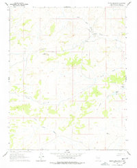
1961 Map of Mesita Americana
USGS Topo · Published 1978About this map
Mesita Americana and the nearby Mesita Camp sit at the center of this 1961 topographical survey of northwestern New Mexico. The landscape is defined by a network of drainage channels, including the North Fork Chico Arroyo and Arroyo Lucero, which cut through the high desert terrain. Human activity in this portion of McKinley County is marked by isolated outposts like the Ball Ranch and essential water infrastructure such as the Demitro Flores Well and Calladito Tank. A notable Landing Strip near the ranch indicates the region's reliance on aerial access for transport and supplies. The survey also identifies prominent local landmarks like VABM 6674 Flores and several arroyos, including Arroyo Padilla and Arroyo Calladito, providing a clear picture of the area's hydrology and land use before later developments.
Find a feature on this map
15 named features on this map. Tap any name to fly to it.
Don’t see what you’re looking for? This feature index may not catch every label — zoom into the map to look around manually.
Map Details
Editions of this 1961 Mesita Americana Map
2 editions found
Other maps of this area

1883 · Mt. Taylor
USGS Topo · 1:250,000

1886 · Mt. Taylor
USGS Topo · 1:250,000

1892 · Mt. Taylor
USGS Topo · 1:250,000

1899 · Mt. Taylor
USGS Topo · 1:250,000

1958 · Albuquerque
USGS Topo · 1:250,000

1961 · El Dado
USGS Topo · 1:24,000

1961 · Piedra De La Aguila
USGS Topo · 1:24,000

1961 · Whitehorse Rincon
USGS Topo · 1:24,000

1961 · Whitehorse
USGS Topo · 1:24,000

1961 · Mesita Del Gavilan
USGS Topo · 1:24,000