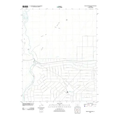
2010 Map of Mesito Reservoir
USGS Topo · Published 2010About this map
San Luis Hills and the winding course of the Rio Grande define this portion of the San Luis Valley, where the river cuts through the terrain at a section known locally as The Box. The landscape reflects a high-desert environment shaped by both dramatic geology and systematic agricultural development. To the east, the Mesito Reservoir and its associated Mesito Dam serve as a focal point for water management in an area marked by a dense grid of county roads, including County Rd-54 and County Rd-21. The intersection of natural landmarks like Music Mesa and Death Valley with this irrigation infrastructure illustrates the human effort to cultivate this arid Colorado plateau. Smaller peaks such as Sugar Loaf, the Brownie Hills, and the Fairy Hills punctuate the northern plains, while Culebra Creek flows westward toward the river, bisecting the network of rural routes.
Find a feature on this map
45 named features on this map. Tap any name to fly to it.
Don’t see what you’re looking for? This feature index may not catch every label — zoom into the map to look around manually.
Map Details
Editions of this 2010 Mesito Reservoir Map
This is the sole edition of this map. No revisions or reprints were ever made.
Other maps of this area

1954 · Trinidad
USGS Topo · 1:250,000

1955 · Trinidad
USGS Topo · 1:250,000

1958 · Trinidad
USGS Topo · 1:250,000

1959 · Trinidad
USGS Topo · 1:250,000

1965 · Lasauses
USGS Topo · 1:24,000

1965 · Blanca SE
USGS Topo · 1:24,000

1967 · Manassa NE
USGS Topo · 1:24,000
1967 · Sky Valley Ranch
USGS Topo · 1:24,000
1967 · Kiowa Hill
USGS Topo · 1:24,000
1967 · Mesito Reservoir
USGS Topo · 1:24,000