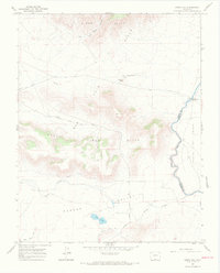
1967 Map of Kiowa Hill
USGS Topo · Published 1971About this map
The Rio Grande snakes along the eastern edge of this 1967 survey, defining the boundary between Conejos and Costilla Counties. This high-altitude landscape is characterized by the prominent volcanic terrain of the San Luis Hills, including the central landmark of Kiowa Hill and the South Piñon Hills. The map captures a moment in the region's agricultural and transit history, featuring the Old State Bridge and the Gaging Station where the river marks the landscape before entering the Sangre De Cristo range.
Find a feature on this map
18 named features on this map. Tap any name to fly to it.
Don’t see what you’re looking for? This feature index may not catch every label — zoom into the map to look around manually.
Map Details
Editions of this 1967 Kiowa Hill Map
3 editions found
Other maps of this area

1954 · Raton
USGS Topo · 1:250,000

1954 · Trinidad
USGS Topo · 1:250,000

1955 · Trinidad
USGS Topo · 1:250,000

1958 · Raton
USGS Topo · 1:250,000

1958 · Trinidad
USGS Topo · 1:250,000

1959 · Trinidad
USGS Topo · 1:250,000

1963 · Pinabetoso Peaks
USGS Topo · 1:24,000

1963 · Ute Mountain
USGS Topo · 1:24,000
1963 · La Segita Peaks NE
USGS Topo · 1:24,000

1967 · Manassa NE
USGS Topo · 1:24,000