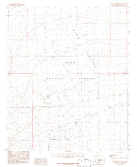
1986 Map of Mesquite Jim Well
USGS Topo · Published 1986About this map
King Valley dominates this arid landscape in Yuma County, Arizona, characterized by its isolation and specialized military usage. The area is largely defined by the sprawling Yuma Proving Ground, where the Military Reservation Boundary delineates a high-activity zone for defense testing. This 1986 survey illustrates the infrastructure supporting these operations, including a network of Gravel Pits and numerous observation points marked simply as Tower. Water management is critical in this environment, as evidenced by the namesake Mesquite Jim Well and various drainage features like the Ditch and several other identified Wells. The map provides a precise layout of the township and range lines, such as T 5 S T 6 S and R 15 W R 14 W, which are essential for navigating this desert terrain during the mid-1980s.
Find a feature on this map
11 named features on this map. Tap any name to fly to it.
Don’t see what you’re looking for? This feature index may not catch every label — zoom into the map to look around manually.
Map Details
Editions of this 1986 Mesquite Jim Well Map
This is the sole edition of this map. No revisions or reprints were ever made.
Other maps of this area

1928 · Norton
USGS Topo · 1:62,500

1929 · Norton
USGS Topo · 1:62,500

1930 · Stoval
USGS Topo · 1:62,500

1942 · Vicksburg
USGS Topo · 1:250,000

1950 · Stoval
USGS Topo · 1:62,500

1953 · Ajo
USGS Topo · 1:250,000

1954 · Phoenix
USGS Topo · 1:250,000

1955 · Growler
USGS Topo · 1:24,000
1955 · Roll
USGS Topo · 1:24,000

1955 · Roll
USGS Topo · 1:62,500