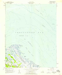
1955 Map of Messick
USGS Topo · Published 1958About this map
The U.S. Military Reservation Plum Tree Island Bombing Range dominates this coastal landscape, showing a significant portion of the York County shoreline dedicated to mid-century military operations. This marshy stretch of the Chesapeake Bay includes the intricate tidal networks of the salt marsh and Drum Island Flats, where the land fragments into numerous small landmasses like Whalebone Island and Cow Island. To the west, the residential patterns of Jeffs, Messick, and Poquoson are established along the higher ground of Blackwalnut Ridge, connected by the primary corridor of Messick Road. Out in the open water, the York Spit Lighthouse stands as a vital navigational marker near the deep-water shipping channel, while the expansive Poquoson Flats highlight the shallow, complex bathymetry of the bay before it reaches the York Spit.
Find a feature on this map
30 named features on this map. Tap any name to fly to it.
Don’t see what you’re looking for? This feature index may not catch every label — zoom into the map to look around manually.
Map Details
Editions of this 1955 Messick Map
This is the sole edition of this map. No revisions or reprints were ever made.
Other maps of this area

1907 · Hampton
USGS Topo · 1:62,500

1916 · Mathews
USGS Topo · 1:62,500

1917 · Mathews
USGS Topo · 1:62,500

1943 · Richmond
USGS Topo · 1:250,000

1944 · Hampton
USGS Topo · 1:24,000

1944 · Messick
USGS Topo · 1:24,000

1944 · Morrison
USGS Topo · 1:24,000

1944 · Harris Grove
USGS Topo · 1:24,000

1948 · Achilles
USGS Topo · 1:24,000

1948 · New Point Comfort
USGS Topo · 1:24,000