
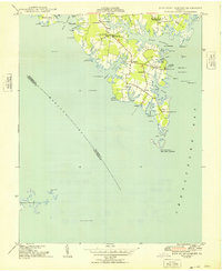
1948 Map of New Point Comfort
USGS Topo · Published 1948About this map
The salt marshes and intricate tidal creeks of Mathews County define this post-war coastal landscape, where the land fragments into points and necks between Mobjack Bay and the Chesapeake Bay. The maritime character of the era is evident in the numerous navigation aids, from the historic New Point Comfort L H at the southern tip to the specialized Whites Island Bar Lt and Pond Pt Shoal Lt. Inland, the community is anchored by local institutions such as Antioch Sch and a network of country churches including St Paul Ch and Beulah Ch.
Find a feature on this map
55 named features on this map. Tap any name to fly to it.
Don’t see what you’re looking for? This feature index may not catch every label — zoom into the map to look around manually.
Map Details
Editions of this 1948 New Point Comfort Map
2 editions found
Other maps of this area

1907 · Hampton
USGS Topo · 1:62,500

1916 · Mathews
USGS Topo · 1:62,500

1917 · Mathews
USGS Topo · 1:62,500

1943 · Richmond
USGS Topo · 1:250,000

1944 · Messick
USGS Topo · 1:24,000

1944 · Harris Grove
USGS Topo · 1:24,000

1948 · Ware Neck
USGS Topo · 1:24,000

1948 · Achilles
USGS Topo · 1:24,000

1948 · Mathews
USGS Topo · 1:24,000

1949 · Richmond
USGS Topo · 1:250,000