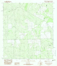
1982 Map of Mesteno Creek South
USGS Topo · Published 1982About this map
Mesteño Creek and Jaboncillo Creek define the drainage of this South Texas landscape along the border of Webb and La Salle counties. This 1982 provisional survey documents a largely undeveloped rangeland environment during the early 1980s, where industrial and utility infrastructure begins to mark the terrain. Evidence of local excavation is visible at a Gravel Pit in the northwest, while an Underground Pipeline cuts across the southern portion of the quadrangle. The map is characterized by its detailed topographic contouring and the presence of an Indefinite Boundary near the eastern edge, reflecting the remote and sparsely settled nature of the brush country during this era.
Find a feature on this map
7 named features on this map. Tap any name to fly to it.
Don’t see what you’re looking for? This feature index may not catch every label — zoom into the map to look around manually.
Map Details
Editions of this 1982 Mesteno Creek South Map
This is the sole edition of this map. No revisions or reprints were ever made.
Other maps of this area

1929 · Cotulla
USGS Topo · 1:125,000

1940 · Velenzuela Creek
USGS Topo · 1:62,500

1953 · Crystal City
USGS Topo · 1:250,000

1955 · Crystal City
USGS Topo · 1:250,000

1956 · Las Tiendas
USGS Topo · 1:62,500

1956 · Webb
USGS Topo · 1:62,500

1956 · Laredo
USGS Topo · 1:250,000

1957 · Encinal
USGS Topo · 1:62,500

1961 · Crystal City
USGS Topo · 1:250,000

1965 · Spohn Ranch
USGS Topo · 1:24,000