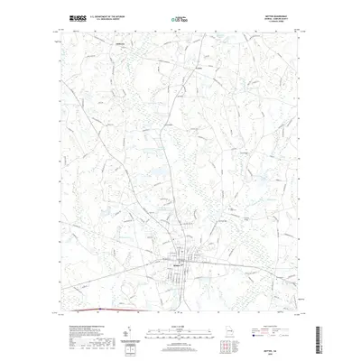
2020 Map of Metter
USGS Topo · Published 2020About this map
Metter serves as the focal point of this Candler County landscape, anchored by the Candler County Courthouse and a grid of streets that transition into a network of country roads. The surrounding area is defined by the winding course of Fifteenmile Cr and its tributaries, including Sams Cr and Stocking Head Cr, which feed several named water bodies like Daughtery Lake North, Cartee Lake, and Hulsey Lake. These waterways are crossed at traditional points such as Jones Bridge and Salem Bridge, reflecting long-established transit corridors between the smaller communities of Union and Olifftown. Genealogists will find significant value in the distribution of family-named burial grounds, including Oliff Cem, Dekle Cem, and Stripling Cem, which are scattered throughout the agricultural and forested lands surrounding the town center. The map reveals a rural economy shaped by these creeks and the many small ponds, like Cooks Pond and Donaldson Lake, that dot the South Georgia terrain.
Find a feature on this map
146 named features on this map. Tap any name to fly to it.
Don’t see what you’re looking for? This feature index may not catch every label — zoom into the map to look around manually.
Map Details
Editions of this 2020 Metter Map
This is the sole edition of this map. No revisions or reprints were ever made.
Other maps of this area

1920 · Statesboro
USGS Topo · 1:62,500

1921 · Rocky Ford
USGS Topo · 1:62,500

1943 · Rocky Ford
USGS Topo · 1:62,500

1943 · Millen
USGS Topo · 1:125,000

1943 · Statesboro
USGS Topo · 1:62,500

1947 · Savannah
USGS Topo · 1:250,000

1948 · Savannah
USGS Topo · 1:250,000

1957 · Macon
USGS Topo · 1:250,000

1957 · Savannah
USGS Topo · 1:250,000

1958 · Macon
USGS Topo · 1:250,000