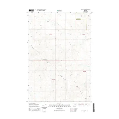
2014 Map of Mexican Buttes
USGS Topo · Published 2014About this map
Mexican Buttes and Twin Buttes dominate the high ground of this Yellowstone County landscape, where the traditional passage of the Musselshell Trail Rd cuts across the drainage basins of the Yellowstone and Musselshell Rivers. The terrain is defined by a complex network of seasonal watercourses and coulees, including Mc Cloud Coulee and Butte Cr, which flow through the northern townships. To the south, the topography transitions into the headwaters of the N Fork Horse Cr and Middle Fork Horse Cr. This 2014 survey documents the enduring physical landmarks of the region, from named elevations like Bender Hill and Ninemile Hill to the long-standing trail roads that historically connected these cattle-country outposts. The presence of the Treasure Co Yellowstone Co line in the northeast corner highlights the administrative divisions within this open rangeland.
Find a feature on this map
15 named features on this map. Tap any name to fly to it.
Don’t see what you’re looking for? This feature index may not catch every label — zoom into the map to look around manually.
Map Details
Editions of this 2014 Mexican Buttes Map
This is the sole edition of this map. No revisions or reprints were ever made.
Other maps of this area

1954 · Forsyth
USGS Topo · 1:250,000

1957 · Forsyth
USGS Topo · 1:250,000

1958 · Forsyth
USGS Topo · 1:250,000

1960 · Coal Bank Creek
USGS Topo · 1:24,000

1960 · Custer
USGS Topo · 1:24,000

1979 · Hysham
USGS Topo · 1:100,000
1979 · Devils Kitchen
USGS Topo · 1:24,000

1980 · Mud Butte
USGS Topo · 1:24,000
1980 · Weed Creek West
USGS Topo · 1:24,000
1980 · Weed Creek East
USGS Topo · 1:24,000