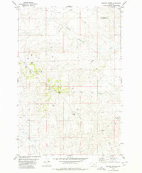
1980 Map of Mexican Buttes
USGS Topo · Published 1980About this map
The rugged high plains of the Yellowstone and Treasure County line dominate this 1980 survey, characterized by prominent landmarks such as Mexican Buttes and Twin Buttes. The landscape is etched by a complex drainage system including Mc Cloud Coulee and North Fork Horse Creek, illustrating the erosive forces at work on this Montana plateau. Evidence of late-20th-century resource exploration is scattered across the terrain in the form of numerous Drill Hole sites, particularly concentrated in the western sectors near Spring.
Find a feature on this map
15 named features on this map. Tap any name to fly to it.
Don’t see what you’re looking for? This feature index may not catch every label — zoom into the map to look around manually.
Map Details
Editions of this 1980 Mexican Buttes Map
This is the sole edition of this map. No revisions or reprints were ever made.
Other maps of this area

1954 · Forsyth
USGS Topo · 1:250,000

1957 · Forsyth
USGS Topo · 1:250,000

1958 · Forsyth
USGS Topo · 1:250,000

1960 · Coal Bank Creek
USGS Topo · 1:24,000

1960 · Custer
USGS Topo · 1:24,000

1979 · Hysham
USGS Topo · 1:100,000
1979 · Devils Kitchen
USGS Topo · 1:24,000

1980 · Mud Butte
USGS Topo · 1:24,000
1980 · Weed Creek West
USGS Topo · 1:24,000
1980 · Weed Creek East
USGS Topo · 1:24,000