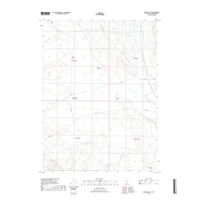
2018 Map of Mexican Flats
USGS Topo · Published 2018About this map
Mexican Flats and the surrounding high plains of Carbon County are defined by a complex network of ephemeral drainages and water management features. The landscape is carved by several prominent draws, including Windmill Draw, Barrel Springs Draw, and South Barrel Springs Draw, which lead toward the larger seasonal flows of Red Wash and Muddy Cr. This 2018 survey reveals the infrastructure of modern land management in an arid environment, notably the Dad Larsen Detention Dam 1593 Number 6 and the Twin Reservoirs near the southern boundary. These features, along with names like Coal Gulch and Blue Gap Draw, suggest a history of resource extraction and ranching utility. The grid of service roads, such as Wamsutter Rd and Straten Rd, provides the primary access across this open Wyoming terrain.
Find a feature on this map
18 named features on this map. Tap any name to fly to it.
Don’t see what you’re looking for? This feature index may not catch every label — zoom into the map to look around manually.
Map Details
Editions of this 2018 Mexican Flats Map
This is the sole edition of this map. No revisions or reprints were ever made.
Other maps of this area

1954 · Rawlins
USGS Topo · 1:250,000

1957 · Baggs
USGS Topo · 1:62,500

1957 · Doty Mountain
USGS Topo · 1:62,500

1958 · Rawlins
USGS Topo · 1:250,000

1962 · Rawlins
USGS Topo · 1:250,000

1967 · Rawlins
USGS Topo · 1:250,000

1970 · South Barrel Spring
USGS Topo · 1:24,000

1970 · Mexican Flats
USGS Topo · 1:24,000
1970 · Flat Top Mountain
USGS Topo · 1:24,000

1970 · Duck Lake
USGS Topo · 1:24,000