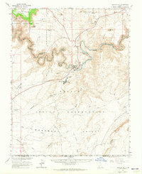
1963 Map of Mexican Hat
USGS Topo · Published 1965About this map
The San Juan River carves a spectacular path through this high desert region, creating the dramatic entrenched meanders known as The Goosenecks. This 1963 field-checked survey, produced in cooperation with the Atomic Energy Commission, highlights the industrial and geological character of southern San Juan County. Near the settlement of Mexican Hat, the presence of Tailings Ponds, an Aqueduct, and a Water Purification Plant reflects the era's mid-century mining and milling activities.
Find a feature on this map
50 named features on this map. Tap any name to fly to it.
Don’t see what you’re looking for? This feature index may not catch every label — zoom into the map to look around manually.
Map Details
Editions of this 1963 Mexican Hat Map
3 editions found
Other maps of this area

1883 · Marsh Pass
USGS Topo · 1:250,000

1886 · Henry Mountains
USGS Topo · 1:250,000

1886 · Abajo
USGS Topo · 1:250,000

1892 · Marsh Pass
USGS Topo · 1:250,000

1892 · Abajo
USGS Topo · 1:250,000

1892 · Henry Mountains
USGS Topo · 1:250,000

1892 · Canyon De Chelly
USGS Topo · 1:250,000

1893 · Abajo
USGS Topo · 1:250,000

1952 · Bluff 3 SE
USGS Topo · 1:24,000

1952 · Dinnehotso
USGS Topo · 1:62,500