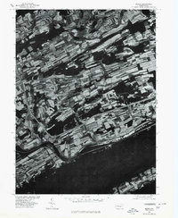
1977 Map of Mexico
USGS Topo · Published 1979About this map
Mexico sits at a prominent bend of the Juniata River, where the waterway carves a deep valley against the massive bulk of Tuscarora Mountain. This 1977 orthophotoquad reveals the intricate strip-farming patterns of Juniata County, where agricultural fields cling to the narrow valleys and ridges typical of the Ridge and Valley Appalachians. To the north, Oakland Mills serves as a small rural hub near Lost Creek, reflecting a settlement pattern dictated by the tight local topography.
Find a feature on this map
7 named features on this map. Tap any name to fly to it.
Don’t see what you’re looking for? This feature index may not catch every label — zoom into the map to look around manually.
Map Details
Editions of this 1977 Mexico Map
This is the sole edition of this map. No revisions or reprints were ever made.
Other maps of this area

1907 · New Bloomfield
USGS Topo · 1:62,500

1907 · Millerstown
USGS Topo · 1:62,500

1925 · Mifflintown
USGS Topo · 1:48,000

1930 · Loysville
USGS Topo · 1:62,500

1933 · Loysville
USGS Topo · 1:62,500

1934 · Mifflintown
USGS Topo · 1:62,500

1937 · Mifflintown
USGS Topo · 1:62,500

1943 · Millerstown
USGS Topo · 1:62,500

1943 · New Bloomfield
USGS Topo · 1:62,500

1950 · Harrisburg
USGS Topo · 1:250,000
Featured Places
- Tuscarora, Turbett Township
- Tuscarora Township, PA
- Fayette Township, PA
- Turbett Township, PA
- Delaware Township, PA